This article may contain affiliate links. If you book through them, we may earn a small commission at no extra cost to you.
On this page
Introduction: The Route That Changed How Japan Thinks About Cycling
In 1999, a series of bridges opened connecting the Japanese mainland (Onomichi) with Shikoku (Imabari, Ehime) across the islands of the Seto Inland Sea. The Nishiseto Expressway (西瀬戸自動車道) — known universally as the Shimanami Kaidō (しまなみ海道) — runs approximately 70 kilometers across six islands: Mukaishima, Innoshima, Ikuchijima, Ōmishima, Hakatajima, and Ōshima.
What distinguishes the Shimanami Kaidō from other bridge routes is the decision to build dedicated cycling paths on every bridge and connecting road — making it the only route in Japan (and one of very few in the world) where you can cross from Honshu to Shikoku by bicycle, on dedicated infrastructure, without competing with automobile traffic on the bridges themselves.
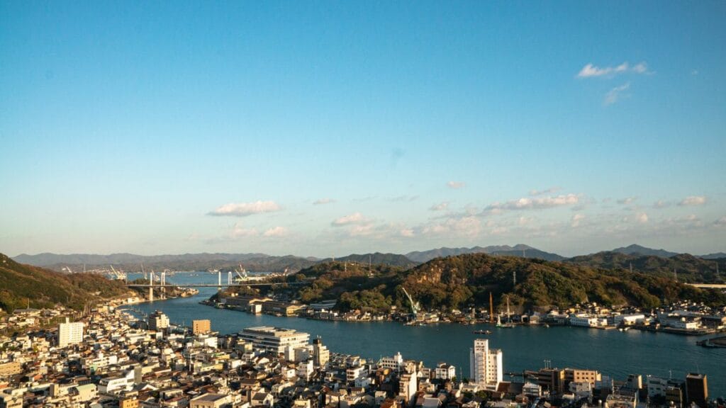
The result is a route that cycling media worldwide has described as one of the most beautiful cycling experiences on earth — not primarily because of the cycling infrastructure (though that is excellent) but because of what you cycle through: the Seto Inland Sea, its hundreds of scattered islands, its constant play of light on water, its fishing villages, its orange and lemon orchards, and the series of increasingly ambitious bridge structures that connect everything.
Getting There and Starting the Route
From the Onomichi Side
Onomichi Station (JR) is the mainland starting point. From the station, a short ferry crossing (¥110, bicycles ¥10) takes you to Mukaishima Island — the first island of the route — and the cycling begins immediately.
Bicycle rental in Onomichi: The most convenient rental facility is Giant Store Onomichi near the ferry terminal, offering high-quality road and hybrid bicycles with English-speaking staff and the most streamlined rental process. The ONOMICHI U2 harbor complex also operates bicycle rental.
From the Imabari Side
Arriving from Shikoku allows you to cycle the route "uphill" (the route has more descent cycling north-to-south than south-to-north due to bridge approach ramps) but gives the option of starting from Imabari and having the train journey to Onomichi after cycling as a restful conclusion. Imabari Station is served by JR Yosan Line.
The Islands: What Each Offers
Mukaishima (向島): The First Island
The shortest island on the route — a quick crossing from Onomichi by ferry, with a short cycling section before the first major bridge. Several hydrangea farms on Mukaishima bloom in June, and the small fishing harbors on the island's southern coast provide the first sense of the Seto Inland Sea island character.
Innoshima (因島): Octopus and the Suigun Pirates
Innoshima is the largest island by population on the route and has a distinctive historical character: it was the base of the Murakami Suigun (村上水軍) — the "sea samurai" who controlled the Seto Inland Sea in the 15th and 16th centuries, collecting tolls from passing ships and providing naval power to whoever contracted them. The Innoshima Suigun Castle (因島水軍城) — a modern reconstruction of a sea castle — contains a museum documenting this maritime warrior culture.
Hakata octopus (はかた蛸): The octopus caught in the waters around Innoshima is considered the finest in the Seto Inland Sea. Takoyaki made with this octopus at the island's harborside stalls is demonstrably different from the mainland version.
Ikuchijima (生口島): The Lemon Island and Kōzan-ji
Ikuchijima is perhaps the most scenically and culturally rich island on the route. Known as the "Lemon Island" for its extensive lemon orchards (which produce Japan's finest domestic lemons — a rarity in a country that imports most of its citrus), the island also contains:
Kōzan-ji (耕三寺): A Buddhist temple whose founder — a wealthy industrialist named Kōzō Kanemoto — spent his fortune from the 1930s to his death in 1970 reproducing in concrete Japan's most important religious buildings at full scale: the Nishi Hongan-ji (West) Gate, the Yōmei-mon from Nikko, and other major landmarks. The result is a surreal and visually overwhelming collection of high-quality reproductions in a single temple precinct. Adjacent to the temple, the Hirayama Ikuo Museum (平山郁夫美術館) houses works by the celebrated painter Hirayama Ikuo (born on the island), whose works depicting the Silk Road in a traditional Japanese painting style are among the finest in 20th-century Japanese art.
Setoda town: The island's main town has a well-preserved historical streetscape and excellent lemon-based food — lemon ramen, lemon tart, lemon sour cocktails at the harborside bars.
Ōmishima (大三島): The Island of Gods
Ōmishima is the most historically significant island on the route — home to Ōyamazumi Shrine (大山祇神社), one of Japan's oldest and most important Shinto shrines, dedicated to the god of mountains, sea, and war. The shrine's treasure house contains the largest collection of ancient Japanese armor in existence — approximately 80% of all armors designated as National Treasures in Japan are held here, donated by warriors across the centuries who came to give thanks for victory.
The main camphor tree in the shrine precinct is estimated to be 2,600 years old — one of the oldest living trees in Japan.
Hakatajima (伯方島): The Salt Island
Hakatajima is known throughout Japan for one thing: Hakata no Shio (伯方の塩) — "Hakata Salt" — a sea salt brand so famous that its television commercial jingle (a simple chorus of "Ha-ka-ta no Shio!" sung by children) has been playing on Japanese television since 1973 and is known to virtually every Japanese person alive. The salt is produced from seawater processed with traditional techniques, and the island's salt factory offers tours.
Ōshima (大島): The Final Island
The route's final island before Imabari is quieter and less developed than the middle islands — a good place to slow down and absorb the full view of the Seto Inland Sea before the final Kurushima Kaikyo Bridge (来島海峡大橋) crossing to Shikoku.
The Bridges: Engineering as Landscape
The ten bridges of the Shimanami Kaidō represent a remarkable range of bridge engineering styles — suspension, cable-stayed, box girder — and each provides a different experience from the cycling path.
The most dramatic is the Kurushima Kaikyo Bridge (来島海峡大橋) — actually a series of three connected suspension bridges crossing the Kurushima Strait, which is famous for its powerful tidal currents. The currents create visible whirlpool patterns in the water below the bridges, and the experience of cycling above this moving water on a bridge that sways slightly in the wind is one of the most physically memorable moments of the route.
View from the bridge: Each bridge's cycling path provides elevated views that cannot be obtained from the island roads below. The perspective of looking back along the route — seeing the previous island diminishing in the distance while the next island grows ahead — gives the most complete visual understanding of the Seto Inland Sea's island geography.
Practical Cycling Information
Road surface: Excellent throughout — dedicated cycling paths on bridges, painted bicycle lanes on island roads, clear blue-line markings on all roads leading to and between bridges.
Gradient: The bridge approach ramps are steep (designed for pedestrians and cyclists, not vehicles) but short. Island road sections are mostly flat to gently rolling with occasional hillside climbs.
Food and water: Convenience stores (7-Eleven, FamilyMart) are present on all major islands. Local restaurants are available in every island's main town.
Accommodation en route: Each island has at least one guesthouse or ryokan for multi-day cyclists. Cyclist's Inn Ōmishima and the Hakatajima hotels are well-regarded cyclist-specific accommodations.
Recommended Base Hotels
- ONOMICHI U2 (Boutique / from ¥18,000): Onomichi starting point, bicycle-integrated design.
- Azumi Setoda (Luxury / from ¥40,000): Ikuchijima island, finest accommodation on the route.
Imabari Washington Hotel (Mid-range / from ¥12,000): Imabari end point, convenient for JR connections to Matsuyama.
Planning where to stay in Chugoku? Browse our honest hotel picks and area guides.
🏨 Planning where to stay?
Every area guide on this site pairs with honest, station-by-station hotel picks. Start here: Ehime Hotel Guides →